geography from watershed divides
I like looking at topographical maps. I found it useful to study geography by looking at natural boundaries like watersheds and their divides. High ridges channel water in the valley between them, where civilization lies, and form boundaries between regions.
For example, continental US has a relatively simple topography characterized mainly by the Cascades-Sierras, the Rockies, and the Appalachian. Continental China, on the other hand, is a lot more complicated, unimaginably complicated, in fact, that it is almost incomprehensible when reading the profuse amount of written descriptions that exist. But I haven’t found a satisfactory visualization on a map, which is a shame, so it is time to make one.
This is an elevation map of China and surrounding areas. It shows all the major geographical features. The elevation coloring is kind of on a log scale, so major color changes correspond to significant elevation changes. I drew in thick yellow lines the major watershed divides and in red labeled the primary regions of China. Descriptions follow.
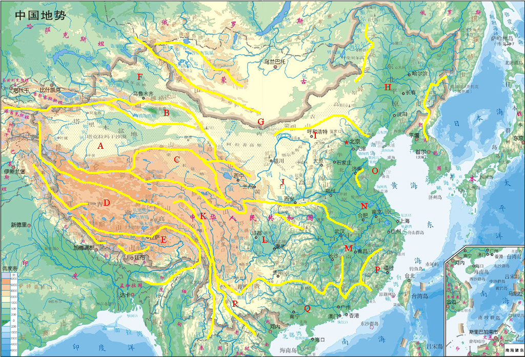
A: Tarim Basin, a depression in southern Xinjiang surrounded by the Tian Shan and foothills in the north, the Kunlun Shan in the south, and filled with the sands of the Taklamakan Desert. Snowmelt flows from the high rim via inland rivers and disappear into the desert. In the eastern end is Lop Nur, a salt marsh. A string of settlements on the rim at the foot of the mountains make up a portion of the Silk Road.
B: Turfan Depression of northern Xinjiang, with Tian Shan and foothills to the south and Bogda Shan in the north.
C: Qaidam Basin, of northwestern Qinghai Province, is a highland basin on the Qinghai-Tibet Plateau, basically a desert with some salt lakes.
D: Southern Qiangtang Plateau, bounded to the north by the Tanglha Range, and to the southwest by the Kailash-Nyenchentanglha Range. It is a highland steppe with salt lakes. The eastern end forms the watersheds of the Irrawaddy River and Salween River, both of which flow through Myanmar into the Indian Ocean.
E: Yarlong Valley, of southern Tibet, an area south of the Kailash-Nyenchentanglha Range and north of the Himalaya Range. The region contains the two largest Tibetan cities, Lhasa and Shigatse. The Yarlong Tsangpo River and tributaries flow through here, eventually becoming the Brahmaputra after the great turn.
F: Dzungarian Basin, of northern Xinjiang, bordered on the south by Tian Shan and Bogda Shan, on the northeast by the Altai Range, and on the southeast by the deserts of Alashan Highland. Urumqi is on its southern rim.
G: Alashan and Inner Mongolian Highlands, encompassing the deserts of the Gobi in its southern portion, bounded on the southwest by the Qilian Range, on the northwest by the Altai Range, on the south by the Yin Mountain, and on the east by Manchuria.
H: Manchurian Plain, bounded on the west by the Great Hinggan, on the east by the Changbai Range, and on the southwest by the foothills of the Yin Mountain. The fortress of Qinhuangdao at the end of the Great Wall on the coast was the traditional pass between inner China and Manchuria till the end of the Qing Dynasty.
I: Inner Mongolian Grassland, between the Yin Mountain in the north and the plains of the south. Hohhot is the major city.
J: Loess Plateau, approximately bounded by the bend of the Yellow River on the west and the north, Qin Range in the south, and Taihang Range in the east, is a high plateau of dry, loose, but fertile soil. The ancient capital of Xi’an sits in its south. The Qin Range divides the Yellow River and the Yangtze River watersheds.
K: Rivers and Ranges. Deriving water from the glaciers in the northern Qiangtang Pleateau between the Kunlun and Tanglha Ranges in the extreme inhospitable west, this area is the headwaters and upstream parts of the Yangtze and Lancang (Mekong), both of which flow into the Pacific. Enclosed on the north (from west to east) by the Kunlun, Kekexili, and Bayankala Ranges, and on the southwest by the Tanglha Range, multiple river valleys of different systems lie near by, interrupted by north-south mountain spines.
L: Sichuan Basin, is completely surrounded by mountains, save for an outlet in the east, Wu Gorge, which is the westernmost of the Three Gorges cut by the Yangtze River. It is bounded by shelf of the Qinghai-Tibet Plateau to the west, the Daba Mountain to the north, and the Dalou Mountain to the south. Its surrounding mountains lie in a temperate zone that is home to the pandas. Chongqing on the Yangtze, which passes through the south of the basin, is the biggest city in central China.
M: Midcourse Yangtze, between the Qin Range to the north and the Southern Range and its foothills, contains the greatest hydrological resources of China. Tributaries of the Yangtze merge at Wuhan. Southern Range is the watershed divide between the Yangtze and Pearl River systems.
N: Great Alluvial Plains, is the vast plain formed by the sedimentary deposits of the two largest river systems of China, the Yellow River, and the Yangtze, along with that of the shorter Huai River originating in the Qin Range in between. The three systems essentially merge in a mesh of waterways, natural and man-made (e.g. the Grand Canal). Beijing sits at the northern tip of the plains.
O: Shandong Peninsula, enclosed by the seas and Mount Tai.
P: Min River Watershed, to the east of the Wuyi Mountain, shows the relative isolation of Fujian. Min River is the major system in Fujian.
Q: Southern China, bounded on the north by the Southern Range, is also known as the “two-Guang” region. This is the drainage basin of the Pearl River and tributaries, the third largest river system of China. The Mei Pass was dug through the Southern Range during the Tang Dynasty to connect this area to the rest of China.
R: Yunnan-Kunmin Plateau, bounded on the north by the Southern Range, and on the south by Wuliang Mountain and foothills, is a subtropical highland region known for the ancient Dali Kingdom and karsts. It is where rivers of southern China and northern Vietnam originate.
